


There is a reason why those who make use of these maps avoid examining their provenance or proving their accuracy: The maps are egregiously, almost childishly dishonest. But they have become so ubiquitous that it is worth taking the time to examine them, and what their dishonesty can teach us about the Palestinian cause and its supporters.
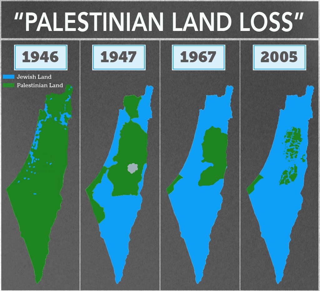
In whatever form they take, the “Land Loss” maps show very little variation. The standard version looks something like this:

Sometimes, a fifth map is added, this one dated 1920, showing the entirety of what was once British Mandatory Palestine in a single solid color, labeled “Palestinian.” This accomplishes the seemingly impossible and makes the series of maps even more dishonest than before.
Whether made up of four or five maps, the message of the series is clear: The Jews of Palestine have been assiduously gobbling up more and more “Palestinian land,” spreading like some sort of fungal infection that eventually devours its host.
There are some outright lies in these maps, to be sure. But the most egregious falsehoods transcend mere lies. They emerge from a more general and quite deliberate refusal to differentiate between private property and sovereign land, as well as a total erasure of any political context.
This final point is especially crucial. It goes to the question of whether the Palestinians actually “lost” this land and the context of that alleged “loss.” We could quite easily, for example, make a panel of maps showing German “land loss” in the first half of the 20th century. It would be geographically accurate but, without the political context, it would tell a completely misleading story amounting to a flat-out lie. And that is precisely what these maps are: A lie.
Taking each map in turn, it is easy to demonstrate that the first one is by far the most dishonest of the lot. As far as I have been able to determine, it is based on a map of Jewish National Fund (JNF) land purchases dating roughly from the 1920s. The JNF was founded to purchase land for Jewish residents and immigrants in then-Palestine, and was partly funded through charity boxes that were once found in almost every Jewish school and organization in the West. Ironically, this map often adorned those ubiquitous boxes.
http://www.thetower.org/article/the-mendacious-maps-of-palestinian-loss/